A CCTV drain survey inspects the internal condition of drainage pipes using a camera system. Utility mapping locates and records the position of buried services beneath the ground surface. These two surveys answer different questions: one tells you what condition a drain is in, the other tells you where underground services are and how deep they run.
In UK construction and property due diligence, confusing the two leads to commissioning the wrong survey, producing incomplete site data, and increasing project risk. Understanding exactly what each service delivers and when to use both together is essential for safe and cost-effective project delivery.
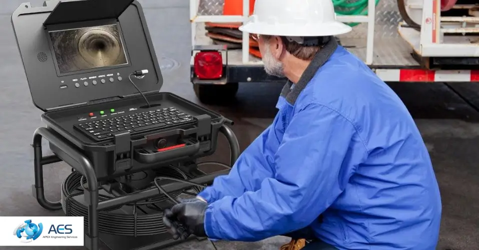
What Is a CCTV Drain Survey?
A CCTV drain survey is a non-invasive drainage inspection method that uses a remote-controlled camera inserted into the drainage system to record the internal condition of pipes, junctions, and manholes. The camera transmits live footage to a mobile van unit, allowing the engineers and surveyor to assess and code every defect encountered.
CCTV drain surveys are used across residential, commercial, and civil engineering projects. These cctv underground pipe surveys are a standard practice for pre-purchase property due diligence, drainage adoption by water authorities, insurance claims, and pre-construction condition assessments.
What Does a CCTV Drain Survey Detect?
A CCTV drain survey detects structural defects and operational obstructions within the drainage system. Findings typically include cracked or fractured pipes, collapsed sections, root ingress through pipe joints, displaced connections, grease and debris blockages, deformed pipe walls, and defective manhole chambers.
What Does a CCTV Drain Survey Report Include?
A CCTV drain survey report includes full video footage of the inspection, still images at defect locations, pipe dimensions and materials, flow direction data, and repair recommendations.
What Is Utility Mapping?
Utility mapping is the process of detecting, locating, and recording the position of buried services beneath a site. These services include gas mains, electricity cables, water mains, telecommunications ducts, sewer runs, and drainage assets. The output is a report that shows service routes, depths, and classifications across the survey area.
Utility mapping is required before any excavation, piling, or ground investigation work. Striking a live buried service during excavation can cause fatalities, project delays, and significant financial loss.
What Technology Is Used in Underground Utility Mapping?
Underground utility mapping uses two primary detection technologies. Electromagnetic (EM) cable and pipe locating equipment traces metallic services by detecting the electromagnetic signals they emit. Ground Penetrating Radar (GPR) transmits radar pulses into the ground and records the reflected signals to detect both metallic and non-metallic services, voids, and subsurface anomalies.
Both technologies are used together on most UK utility surveys to maximise detection coverage. Metallic services such as gas mains, electricity cables, and steel water pipes are detectable by EM equipment. Non-metallic services such as plastic water mains, HDPE ducts, and fibre optic conduits require GPR to be identified.
What Are PAS 128 Survey Levels?
PAS 128 is the British Standard specification for underground utility detection, verification, and location. It defines four survey quality levels that determine how thoroughly buried services are investigated.
Level D is a desktop study using existing utility records from network operators. Level C is a site walkover that visually locates surface features such as manholes, valve boxes, and marker posts. Level B is a geophysical survey using EM and GPR equipment to actively detect buried services. Level A is a ground-truth investigation using vacuum excavation or physical exposure to confirm the exact position and depth of a specific service.
Most pre-construction utility surveys are carried out to PAS 128 Level B as a minimum. Level A is used where critical service positions need physical verification before high-risk excavation or piling.
CCTV Drain Survey vs Utility Mapping — Key Differences
|
Feature |
CCTV Drain Survey |
Utility Mapping |