Hydrographic and Bathymetric Surveys
Our Hydrographic and Bathymetric Surveys Services provide precise, high-resolution mapping of underwater environments, tailored to meet the needs of diverse projects involving rivers, lakes, reservoirs, and other bodies of water.
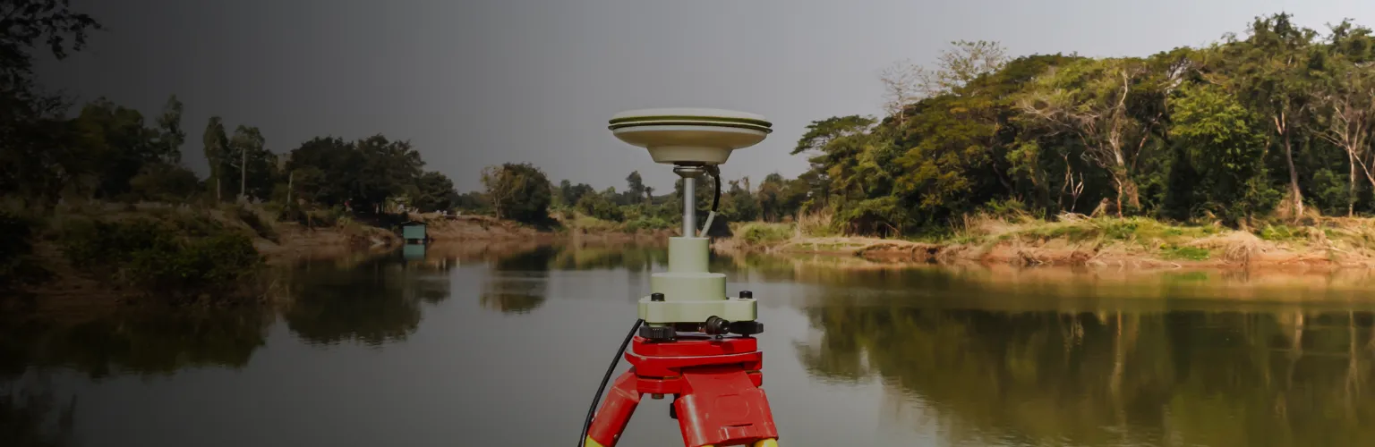
Leveraging advanced sonar and GPS technology, we capture critical data on water depths, seabed contours, and submerged structures, providing the reliable information needed for dredging, construction, environmental assessments, and flood risk management. With a focus on safety, accuracy, and efficiency, our surveys are invaluable for effective planning and sustainable management in challenging aquatic settings.
Why Choose Our Hydrographic and Bathymetric Surveys Services?
Our hydrographic and bathymetric surveys offer a comprehensive understanding of underwater landscapes, enabling clients to make informed decisions. From identifying hazards to ensuring compliance with environmental standards, our services support a wide range of aquatic projects. Key benefits include:
- Enhanced Decision-Making: Detailed underwater mapping offers insights that aid in project planning and resource allocation, reducing potential project risks.
- Safety Assurance: With high-resolution data on water depths and submerged structures, clients can plan projects with safety and environmental preservation in mind.
- Custom Solutions: We provide tailored surveys to meet the unique demands of each project, whether it involves small fishing lakes or extensive reservoirs.
Advanced Technology for Accurate, Efficient Surveys
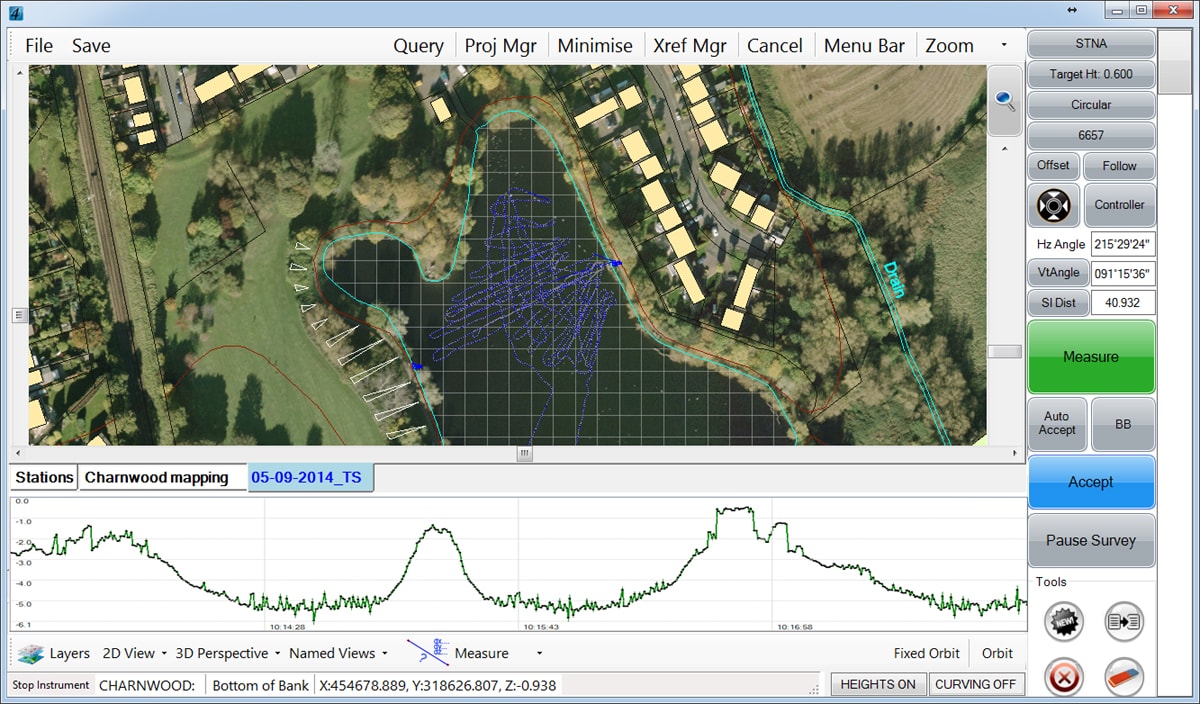
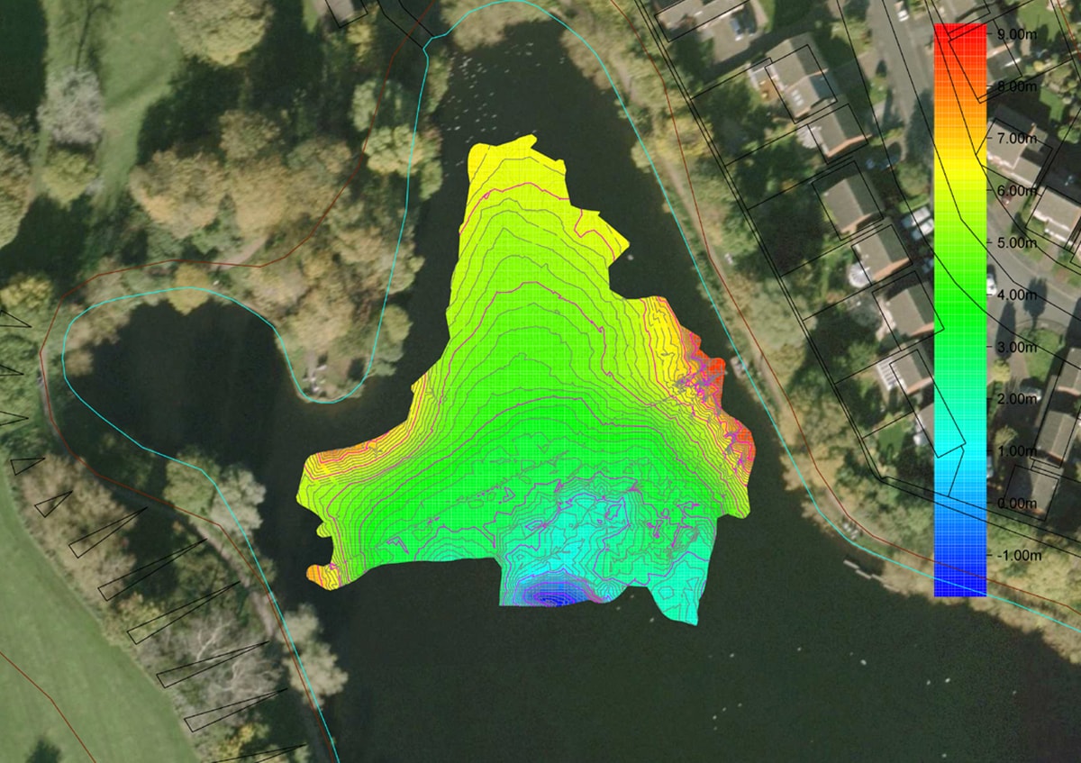
Our team uses cutting-edge multi-beam and single-beam sonar systems, integrated with GPS technology, to collect detailed bathymetric data swiftly and accurately. This advanced equipment captures precise depth measurements and underwater topography, providing a full representation of the area surveyed. Our methods enable rapid, safe data collection, even in challenging or remote aquatic locations, ensuring that clients receive accurate, actionable insights without delay.
Comprehensive Survey Outputs
Our hydrographic and bathymetric surveys are delivered in multiple formats, including detailed 2D and 3D maps and contour plots, all compatible with industry-standard software for seamless integration into planning and design workflows. With high-resolution imagery and data points, our deliverables support various project stages, from initial site analysis to final project completion, ensuring a streamlined workflow.
Benefits of Apex Hydrographic and Bathymetric Surveys
Our hydrographic and bathymetric surveys services provide clients with critical data that supports safe and efficient project execution. Key benefits include:
- Fast and Cost-Effective Solutions: Advanced technology allows us to perform surveys efficiently, reducing time and cost without sacrificing accuracy.
- Comprehensive Data Capture: Our surveys provide precise information on water depths, geographical features, and both natural and artificial navigational hazards.
- Reliable Planning Support: From dredging to environmental studies, our data serves as a solid foundation for effective planning and risk mitigation.
Applications of Our Hydrographic and Bathymetric Surveys Services
Our services are adaptable to a range of applications and industries, providing essential data for:
- Dredging and Construction Projects: Supporting infrastructure projects by mapping underwater contours and identifying obstacles that may impact construction.
- Environmental Studies: Assisting environmental consultants researchers in assessing aquatic ecosystems and identifying impacts on water quality and biodiversity.
- Flood Risk Assessments: Providing data that supports flood modelling and risk management, ensuring preparedness in areas vulnerable to flooding.
- Navigation and Safety: Ensuring safe navigation by identifying underwater hazards, assisting both commercial and recreational vessels in secure route planning.
AES Featured Clients


© 2026 All Copyright rights reserved APEX Engineering Services Ltd.