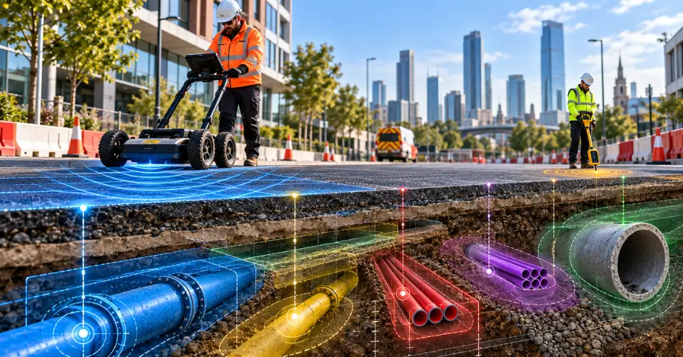
PAS 128 survey is a main component that sets out a reliable foundation for construction. However, the accuracy can be explicitly demonstrated through the utilisation of advanced technologies to map hidden pipes, and QCF Level 3-trained professionals will conduct this survey.
No matter what type of project you are aiming for, whether residential or commercial, it will be risky if you neglect to properly inspect the underground and above ground. It will be dangerous for workers as well because during excavation you never know what you might hit. So, through this blog, you will be recognising that the integration of a PAS 128 survey is not simply important but compulsory.
What is a PAS 128 Survey?
It was first introduced in 2014 with the main purpose of detecting underground gas pipes, water pipes, and electric cables, so that there will be no hindrance in the completion of the project. Then, in 2022, it was ensured that a PAS 128 utility survey was conducted using dependable methods and advanced equipment that provides high-quality data.
The Different Accuracy Levels of PAS 128 Surveys
There are four major types of PAS 128 surveys; each has its own significance in construction:
QL-D: The Desktop Baseline
It is the basic initiating step of any project where contractors do research by collecting information from asset owners like an electricity distributor or water company.
But the only drawback is that the recorded data can never be guaranteed as fact because utility infrastructure changes with the passage of time.
QL-C: Adding Eyes on the Ground
After gaining a complete understanding regarding the location of utilities, the surveyor experts go into the field and try to match the information with physical evidence at the subsurface level, including manhole covers, valve covers, and tangled electric cables.
QL-B: Where Geophysical Detection Comes In
In construction, simply doing research and identifying what is present on the ground is not enough, as the tables will be turned when what is present beneath the ground is examined.
For that, the experts at Apex Engineering Services will rely on the functionalities of advanced tools because accuracy is always prioritised by project owners.
Therefore, in order to detect metallic pipes and power cables, radio frequency technology is being employed to determine the exact location through precise signals.
QL-A: Physical Proof
The last category is about uncovering the surface beneath with non-destructive vacuum excavation so that no damage will be done to any verified pipes.
Benefits That AES Derives from PAS 128 Utility Survey
The support of their engineers brings precision and efficiency in the management of construction.
- Having no knowledge of underground utilities can not only extend the timeline of project completion, but since the foundation is unpredictable, the overall structure will be at risk. Most importantly, this lack of knowledge might become the reason why any constructor gets hurt.
- Their QCF Level 3-trained professionals will meet your expectations by giving you accurate data on the mapping of drainage or sewer pipes. Therefore, no extra cost will be required because no damage occurred on site.
- The use of a total station and GPS/GNSS plays a vital role in bringing accuracy to topographical surveys, also preferred in PAS 128 surveys to ensure safe planning and development.
What is the process of undertaking a PAS 128 Survey?
Initially, a proper plan has been made by the engineers of AES, such as where to begin and what strategies will be the centre of attention. This is also discussed openly with project owners.
Next, the data will be gathered from reliable sources relevant to the location of hidden pipes and cables.
Then the experts thoroughly inspect the subsurface and underground. As they have years of experience in this field, these professionals at Apex Engineering Services know which tool is ideal to identify the precise spot of telecommunications cables or gas pipes.
FAQS
What are the four PAS 128 Quality Levels?
QL-D (desktop records only), QL-C (records plus surface reconnaissance), QL-B (geophysical detection using EML and/or GPR), and QL-A (physical verification via excavation). Each level builds on the one before it.
PAS 128 Type B surveys have four quality levels (QL-B1 to QL-B4) showing the confidence and accuracy of buried service detection.
PAS 128 Type B Quality / Confidence Levels
- QL-B1 (Highest Confidence): The utility clearly and continuously traced. Both electromagnetic locating (EML) and ground-penetrating radar (GPR) strongly support its horizontal position and depth.
- QL-B2 (Good Confidence): The utility continuously traced with consistent depths but verified by only one geophysical technique (either EML or GPR).
- QL-B3 (Moderate Confidence): The utility was detected by at least one geophysical method, but there is no reliable depth measurement or continuous signal trace.
- QL-B4 (Lowest Confidence): The utility is expected to exist based on desktop records (QL-D/C), but it could not be detected on-site. It is shown as an assumed route with no confirmed horizontal or vertical position.
What's the difference between QL-B1 and QL-B4?
Both fall under QL-B, but confidence varies: B1 means a service was traced continuously and confirmed by more than one detection method, while B4 means the service is only assumed to exist because it couldn't be detected at all; it's the weakest sub-level within QL-B.
Is QL-D data safe to dig by?
No. QL-D is a desktop-only records search with no site verification, so it's suited to early feasibility planning, not excavation. Records are often outdated or incomplete.
Which Quality Level is needed for actual excavation or design work?
QL-B (ideally B1/B2 confidence) is generally the practical minimum for safe excavation planning. QL-A is reserved for high-risk points like piling or deep foundations, where certainty is critical.
Does a higher Quality Level guarantee a utility is exactly where it's shown?
No, even QL-A only verifies the exact point that was exposed, not the entire route. PAS 128 grades confidence, not certainty; it tells you how reliable the data is, not that it's infallible.
Conclusion
Perhaps the most important thing to know about PAS 128 accuracy levels is how every step is connected with each other. For instance, QL-A is entirely dependent on QL-B and QL-C, or vice versa. Because a surveyor cannot go empty-handed without knowing any previous history of the site just to visualise and start their operation. However, you might not know that it damaged the gas pipe or any water pipe, which only causes delays in the project.
What a PAS 128 utility survey really gives is transparency. That you can have certainty in what you know, and how much confidence you can apply to any statement about underground services based on the level of accuracy. That is significant to anyone planning, designing, or excavating. So, reach out to Apex Engineering Services because their experts understand what every project demands.