Accuracy is not only a technological need but also a legal one in property development. Apex Engineering Services' topographical surveys are important for this reason. Their professional engineers offer trustworthy data for contracts, guarantee adherence to construction laws, and assist in preventing boundary conflicts. Hence, legal issues may surface in the absence of accurate land data, resulting in delays and unforeseen expenses.
The Legal Backbone of Every Project: Why Topographical Surveys In The UK Are Essential
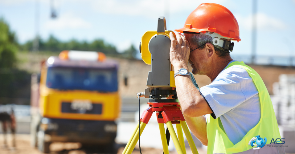
Legal clarity in property development is based on topographical surveys. The constructors need to know what they are building on when they start a new project, whether it's residential or commercial. For that reason, AES offers comprehensive surveys that display elevation levels, subterranean utilities, and man-made and natural elements. Not only is this knowledge helpful, but it is also necessary to comply with safety regulations and getting property development planning permissions.
Moreover, the constructors can stay clear of legal problems like boundary violations and inappropriate site usage with the use of these surveys. Thus, any error committed during the planning stage could later become a significant legal problem if a suitable survey isn't conducted.
Avoiding Legal Disputes Through Precision
A border dispute is one of the most significant threats to land development. Property line disputes can harm a company's reputation, cause delays in building, and raise litigation expenses. This is avoided by AES topographical surveys, which precisely map the geographical characteristics. To precisely designate boundaries, their engineers use advanced technologies like GPS and 3D modelling in surveys.
Buildings, fences, roads, and access points are all kept within the bounds of the law thanks to these measurements. The engineers of AES's use topographical surveys report as legal proof if there is a dispute with a nearby property. This can keep the project on schedule and assist resolve problems swiftly. Because of consistent accuracy, AES is consider the best company you can rely on to get the high-quality engineering and surveying solutions.
Supporting Contractual Agreements with Accurate Data
A crucial part of any development is contracts. Accurate measurements of land area, buildings, and access points are frequently necessary for these agreements. To draft legally binding contracts, contractors, and legal teams can use the precise data that AES topographical surveys offer ensuring compliance with land survey legal requirements.
For example, each party must be aware of the location and size of any shared access roads that are part of the project. AES's surveys help in the precise definition of these components. Conflicts between contractors, investors, and potential property owners are avoided when survey data is correct.
Minimising Construction Risks and Liability
Risk reduction is a significant advantage of AES's topographical surveys. Sometimes there are chances that constructor run into major legal issues if they begin development without knowing where drainage lines or subterranean utilities are located. Lawsuits, penalties, or safety risks may result from unintentional damage to these systems.
That is why the expert engineers of AES locate hidden objects and subterranean utilities via laser scanning. So, by ensuring compliance with topographical survey regulations, they help reduce legal issues during construction and lessens the likelihood of expensive delays brought on once work has started.
Saving Time and Money with Legally-Ready Surveys
In property development, time is money. Legal problems that surface midway through a project can need rework and result in costly delays. Therefore, AES's (Apex Engineering Services) thorough topographical surveys in the UK, which include all relevant information up front, help prevent unexpected surprises.
Councils, planners, and legal experts also accept their surveys. This eliminates the need for constructors to order extra reports or justifications. AES engineers provide data in both print and digital formats that are immediately used in court documents or planning sessions. Hence, every phase of development, from initial planning to final approval, is accelerated by this efficiency.
What are the common queries of people regarding AES?
Why are topographical surveys important for legal compliance in property development?
Topographical surveys provide accurate data about land boundaries, elevations, and existing features. This information helps constructors meet zoning laws, building codes, and planning requirements. Without it, legal issues like boundary disputes or non-compliance with local regulations may arise.
Can a topographical survey prevent property boundary disputes?
Yes, it can. A detailed topographical survey in the UK marks the exact limits of a property, which helps avoid conflicts with neighboring landowners. In case of disagreement, the survey serves as official documentation to support legal claims.
How do topographical surveys affect planning permission approval?
Planning authorities often require topographical data to evaluate a project. Surveys reveal site conditions like slope, drainage, and nearby features, allowing planners to assess whether a development complies with environmental and zoning rules. This makes approval easier and faster.
Are topographical surveys legally accepted in property contracts and agreements?
Absolutely. Legal teams use these surveys to define land area, access points, and structures within contracts. Accurate data ensures that all parties understand and agree on property details, reducing the risk of contract disputes.
What happens if a developer skips a topographical survey before building?
Skipping a topographical survey in the UK increases the risk of building on the wrong land, damaging underground utilities, or violating local laws. These mistakes can lead to legal action, fines, construction delays, or forced modifications, all of which cost time and money.
Conclusion
Knowing your land is the first step towards achieving legal certainty in property development. This assurance is provided by AES's topographical surveys, in which their engineers use precise, and expert land mapping. By guaranteeing safe design, planning compliance, and boundary accuracy, these surveys assist constructors in avoiding legal problems.
Furthermore, using AES's topographical surveys in the UK gives you legal project protection in addition to technical data. To put it briefly, they transform dangers into safe steps forward and unknowns into facts. So, contact AES because these surveys are necessary not optional for any serious developer.