When you choose a topographical survey, it is quite simple to believe that all surveys are the same. But this is not true. Because even minor errors might cause major issues, such as delays, poorly designed sites, or even legal issues.
Although Apex Engineering Services provides detailed topographical surveys, there are still some mistakes that you can avoid to receive the best results.
Five pitfalls to avoid when selecting their services are highlighted in this blog.
-
Overlooking the Scope of the Survey
Ignoring the extent of the topographical survey is one of the most common blunders people make. Some believe that a simple land plan will suffice. But through that survey, the experts of Apex Engineering Services assess drainage networks, utility lines, and ground levels, among other things.
You risk missing important subterranean features or property boundaries if you merely ask for a limited area survey. These mistakes could lead to issues during development or construction. Always make sure to talk to their engineers about all of your project requirements.
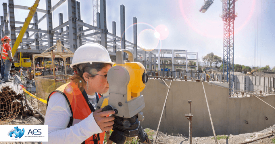
To gather precise data, their team, who offer boundary survey services in the UK, makes use of GPS/GNSS and total stations. Therefore, you receive the most comprehensive and practical survey when you properly specify your scope.
-
Not Asking for 3D or CAD-Compatible Outputs
Not requesting the correct file formats is another mistake. A lot of customers merely go for printed maps or basic PDFs. However, Apex Engineering Services can produce advanced digital outputs in 2D and 3D that are compatible with CAD and BIM tools.
Early in the design process, these digital models assist engineers and architects in making better choices. They are able to view boundary lines, topographical problems, and elevation variations in one location. You might have to retake the survey if you neglect these formats.
-
Ignoring Utility and Underground Feature Mapping
Ignoring the mapping of subsurface drainage networks or utilities is a grave error. A common misconception is that topographical surveys in the UK only display what is at the top. But reality is totally opposite because through this survey, you know about the subsurface level as well.
Without this information, subterranean cables or pipes could be damaged during construction or excavation. This causes the project to be delayed in addition to increasing costs. Therefore, it has been proven that this thorough survey is important to avoid expensive surprises later.
-
Choosing Based on Price Alone
Although price plays a significant role, you should never choose a survey just based on its cost. Some clients search for an affordable survey without considering the features. Usually, this results in less data, poorer quality, or no format choices.
Apex Engineering Services prioritises technology, precision, and compliance. They use advanced machinery to deliver excellent outcomes that satisfy UK planning and legal requirements.
You won't have to pay much more later to correct errors after selecting a topographical survey in the UK.
Lastly, if you have any confusion regarding the importance of topographical surveys in construction, then read the full article on it.
-
Failing to Discuss Project Timelines and Delivery Formats
A lot of clients neglect to confirm the method and timing of receiving the final survey findings. Project planning may suffer if deadlines are unclear. Apex Engineering Services provides quick and adaptable delivery of boundary survey services in the UK, but only if you express your needs properly.
Will you require paper copies, digital plans, or both? Do you have a planning deadline and need the findings immediately? These are important questions. You risk delaying your project's future stages if you don't address delivery formats or timelines up front.
The professionals of Apex Engineering Services modify their procedure to your preferred format and timeline when there is clear communication.
What are the questions that people have for Apex Engineering Services?
What should I check before selecting a topographical survey company?
Before choosing a survey company, make sure they offer detailed mapping, use advanced technology, and provide digital formats like CAD or 3D models. Also, confirm if they include underground utilities and meet UK survey standards.
Why is it risky to choose a topographical survey based on low price alone?
A low-cost survey might not include all the essential details, such as underground services or digital outputs. This can lead to project delays, legal issues, or extra costs later. It’s better to focus on value, not just price.
Do I really need a 3D or CAD version of the survey?
Yes, if you're working with architects or engineers, having CAD or 3D files helps with accurate planning and design. It saves time and reduces mistakes during construction, especially for complex projects.
Is mapping underground utilities part of a topographical survey?
Not always, but it should be. Many companies treat it as an extra service. However, Apex Engineering Services provides an accurate representation of utilities and drainage systems to avoid construction damage or safety risks.
How can I make sure the survey is delivered on time and in the format I need?
Discuss your deadlines and file format preferences with the survey team in advance. A professional company like Apex Engineering Services can adjust its process to meet your needs if you're clear from the start.
Conclusion
Apex Engineering Services is well-known for doing trustworthy topographical surveys in the UK. To get the best results, however, even the best service providers require explicit client participation. You can save time, cut expenses, and guarantee a smooth project journey by avoiding these five frequent mistakes: picking by price, neglecting utilities, ignoring scope, omitting digital formats, and forgetting to negotiate delivery.
So, reach out to Apex Engineering Services, and they will assist you in building with clarity and confidence if you make a wise decision.