Exposing what is concealed in the depths of the water, it provides a strong foundation for the construction projects near water bodies.
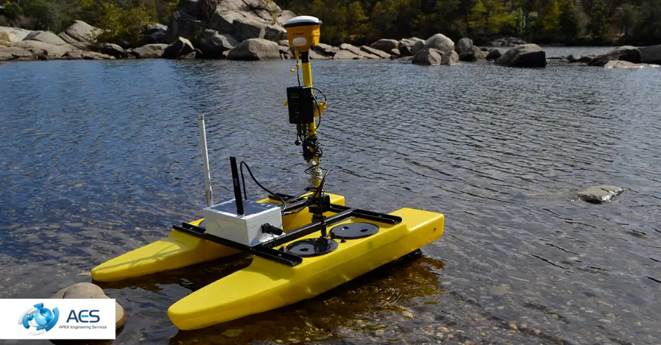
The expert surveyors of Apex Engineering Services employ advanced technologies, including sonar beams and GPS, to measure the accurate depths of water, seabed contours, and identify submerged structures. However, the precise findings will lead to safety and efficiency during the project.
This blog will shed light on the role of hydrographic surveys in construction planning and also on how engineers conduct this survey.
What is a Hydrographic Survey?
Comprehension of the underwater landscape is the primary focus of this survey. Capturing vital data through modern tools assists constructors in making informed decisions regarding equipment, personnel, material, and finances during construction.
Moreover, the safety of your project is ensured through this survey, since high-resolution data on submerged structures and water depths is provided to the client.
Technologies That Are Core Components of The Survey
Multi-beam sonar provides denser data coverage, while single-beam sonar captures depth along individual lines. In that 3D digital terrain, all the pipeline routes and potentially hazardous obstacles are identified to prevent delays in construction.
Complete Process of Conducting a Hydrographic Survey
First of all, the engineers of AES begin with the accurate positioning of all technologies, system alignment, and validation check which is a quality control process through which they analyse that the collected bathymetric data (water depths and seabed features) is appropriate.
Most importantly, the surveyors do not just wander off in the water but rather follow a planned parallel line or grid pattern to ensure comprehensive coverage. With the help of GPS, they guide the vessel along these lines to avoid any gaps in the data.
Next, after assembling the data from the bathymetric survey comes processing, in which removing outliers and cleaning up the data is involved. Because through this information, the engineers create a digital model in three dimensions that underlines topography, depth, and structural composition of the underwater environment, by utilising color-coded bathymetric data to represent depths.
Furthermore, if you demand an extreme level of precision in your project, then Apex Engineering Services will deliver results of underwater mapping in various formats, like 2D and 3D, that will be compatible with industry-standard software.
Compulsion of Hydrographic Survey In The Construction and Beyond
With accurate underwater mapping, constructing bridges or waterfront structures is safer, more efficient, and free from unexpected hazards.
As the complete map of the underwater landscape is laid down in front of you with accurate depth measurements and detection of irregular soil deposits, this will simplify every phase of construction.
Additionally, this hydrographic survey is more than just about construction, because it plays a significant role in safeguarding natural habitats and exploring underwater resources. Bathymetric data helps engineers assess potential impacts from natural events such as tsunamis, hurricanes, or coastal flooding, aiding in risk mitigation and planning.
What are the questions that people have for Apex Engineering Services?
What is the difference between hydrographic and bathymetric surveys?
Hydrographic surveys in the UK focus on mapping underwater features such as seabed conditions, submerged structures, and water depths, while bathymetric surveys specifically measure the depth and shape of the underwater terrain. Together, they provide a complete picture of underwater environments, which is essential for safe construction planning near water bodies.
Why are hydrographic and bathymetric surveys important for construction projects near water?
These hydrographic surveys in the UK help identify hidden underwater hazards, uneven seabed conditions, and depth variations that could impact foundations or construction equipment. By understanding these factors early, engineers can reduce risks, prevent costly delays, and ensure the structural safety of projects like bridges, docks, and waterfront developments.
How do these surveys improve safety during construction planning?
By delivering high-resolution data on water depths and submerged obstacles, hydrographic and bathymetric surveys allow engineers to plan construction methods more accurately. This minimises unexpected ground conditions, reduces risks to workers and equipment, and ensures compliance with safety and engineering standards.
What technologies are used in hydrographic and bathymetric surveys?
Modern surveys use advanced tools such as single-beam and multi-beam sonar systems integrated with GPS technology. These tools collect precise depth measurements and seabed data, which are then processed into detailed 2D and 3D models for accurate analysis and construction planning.
How do survey results support better decision-making in construction projects?
Survey results provide engineers with reliable data on underwater topography and soil conditions, helping them choose the right construction techniques, materials, and equipment. This leads to better cost control, efficient project execution, and long-term stability of structures built near or over water.
Conclusion
In order to ensure safe and effective construction near water bodies, hydrographic and bathymetric surveys are essential. These surveys give engineers a comprehensive grasp of underwater conditions, which aids in risk identification, precise planning, and the avoidance of expensive building surprises. However, with the use of advanced technology and knowledgeable analysis, hydrographic surveys help ensure long-term sustainability and environmental preservation in addition to providing solid project foundations.
Contact Apex Engineering Services if you want to integrate three significant elements: safety, accuracy, and efficiency in your project.